Your Assets Are Moving. Do You Know Where They Are?
How GPS-Based Inventory Monitoring Converts Barcode Scans into an Active Asset Map
The majority of companies are aware of their owned assets.
The more challenging inquiry is:
Do you know precisely where every asset is located at this moment?
A generator may move to another job site. Construction equipment may be transferred to a different project. Utility assets may be installed across a large service area. Materials, tools, vehicles, and field equipment can be distributed across numerous or even countless locations.Conventional inventory systems can inform you of what you possess, but they frequently cannot indicate its location.
Using GearChain, your mobile device transforms into a GPS-equipped asset tracking device.
You can read a barcode or QR code, log asset details, obtain GPS coordinates, and refresh the information instantly.
The location information can be displayed in the GearChain app and synchronize immediately with Google Sheets or Excel, providing your team an easy method to monitor both the asset and its most recent known location.
From Barcode Scan to GPS Coordinates in Seconds
With GearChain, you can create a custom inventory form that includes a GPS Coordinates field.
When an employee scans an asset code using a mobile device, GearChain can record information such as:
Asset ID
Asset name
Category
Quantity
Condition
Photos
Notes
GPS coordinates
Date and time
User activity
The collected information is saved in GearChain and synchronized with Google Sheets or Excel-compatible data.
There is no need to manually type latitude and longitude, update a separate location spreadsheet, or wait for someone to submit a field report.
The user simply scans the code, reviews the asset information, and saves the record.
How to Create a GPS-Enabled Form in GearChain
Building a form with GPS tracking in GearChain is easy. You can create the form from either the mobile app or the desktop version.
Create a GPS Form on Mobile
On your mobile device, follow these steps:
Open Settings.
Select Form Settings.
Tap Create a New Form.
Enter a form name and choose a template.
On the Form Design page, open the field dropdown.
Select GPS Coordinates to add it to the form.
Save the form.
Create a GPS Form on Desktop
On the desktop version, follow these steps:
Open Settings.
Go to Form Settings.
Select Create New Form.
Enter a form name and choose a template.
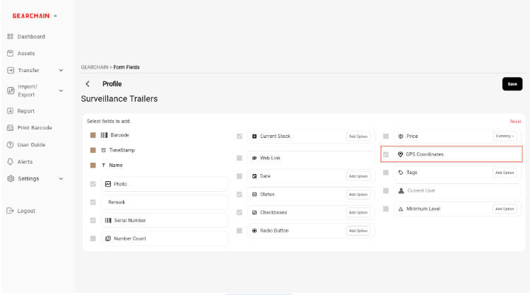
On the Form Design page, make sure GPS Coordinates is selected.
Save the form.

- Design a tailored GearChain form and include GPS Coordinates as a field. -
After creating the form, access it on a mobile device, scan a barcode or QR code for an asset, and store the record.
GearChain will capture the GPS coordinates together with the asset information.
The saved data can then appear in the GearChain app and sync with Google Sheets or Excel for reporting, analysis, and map visualization.
Turn Your Inventory Spreadsheet Into a Live Asset Map
One of the biggest challenges in asset management is understanding where assets are physically located.
A spreadsheet may tell you that your company owns 100 generators, vehicles, tools, or machines. However, it may not clearly show where each item is currently located.
With GPS-enabled inventory tracking, your spreadsheet becomes much more useful.
You can track assets such as:
Power towers
Generators
Construction equipment
Trees and landscaping assets
Construction materials
Vehicles and trailers
Medical equipment
Facility assets
Utility infrastructure
Field tools and machinery
Each scan records the asset’s location and updates your inventory data.
Because GearChain can synchronize with Google Sheets, you can connect the spreadsheet to Data Studio(Formerly Looker Studio) and display the GPS coordinates on a map.
This allows you to create a visual dashboard showing:
Where each asset is located
Which assets belong to each job site
How assets are distributed across different areas
The latest scanned location of each item
The date and time of the latest update
Asset movement between locations
Your inventory is no longer just a list of records. It becomes a live view of your physical assets.


- Each scanned asset is saved with its GPS coordinates and updated in real time. -
Visualize Asset Locations With Data Studio and Google Maps
When your GPS data is accessible in Google Sheets, you can link the sheet to Data Studio.
Data Studio can use the latitude and longitude data to display asset locations on a map.
For example, you could build a dashboard that shows:
Generators across multiple construction sites
Power towers across a service area
Trees and landscaping assets across a city
Vehicles across warehouses and job sites
Equipment assigned to different projects
Materials stored at different outdoor locations
Managers can utilize the map to swiftly grasp the locations of assets without sifting through rows of spreadsheet information.
Filters can be added for asset type, location, project, status, employee, or date as well.
This facilitates the examination of numerous assets and pinpointing the locations of particular items.


- Connect GearChain data in Google Sheets to Data Studio and visualize your assets on an interactive map. -
Update Asset Locations Whenever They Move
Physical assets are rarely stationary.
Construction companies move equipment between projects. Utility companies relocate field equipment. Businesses transfer inventory between warehouses. Vehicles and trailers move throughout the day.
With traditional tracking methods, location updates may depend on phone calls, handwritten notes, or someone remembering to update a spreadsheet.
With GearChain, the process is much simpler.
When an asset moves:
A team member scans the asset code using a mobile device.
The current GPS coordinates are captured.
The new record is saved in GearChain.
The updated information syncs with Google Sheets.
The new location can appear in the connected map or dashboard.
Whenever the asset is scanned at a new location, its latest coordinates can be recorded.
This gives your team a practical way to keep asset location data current through normal scanning activity.
Example: Tracking Construction Equipment Across Multiple Job Sites
Imagine a construction company managing:
50 generators
100 pieces of equipment
Hundreds of tools
Thousands of construction materials
Multiple active job sites
In the absence of a location-based tracking system. Project managers might have to contact various teams. Review multiple spreadsheets. Or wait for field reports to find out the whereabouts of equipment.
With GearChain, a worker can scan the equipment code when it arrives at a new site.
The system can record:
The asset name
The asset ID
The project or location
The current GPS coordinates
The scan date and time
The employee who performed the scan
Notes or photos
The project manager can then review the latest information in GearChain, Google Sheets, Excel, or a Data Studio map.
This reduces manual reporting and gives the team a clearer view of where equipment is being used.
Example: Mapping Utility and Outdoor Assets
GPS-enabled forms are also useful for assets that are installed outdoors or spread across large areas.
For example, a utility company could track:
Power towers
Transformers
Generators
Meters
Street equipment
Maintenance assets
A landscaping company or city department could track:
Trees
Irrigation systems
Benches
Signs
Lighting
Public equipment
A field employee can scan the asset, capture the GPS coordinates, add notes or photos, and save the record.
The data can then be mapped to help teams plan inspections, maintenance, repairs, or replacements.
More Than GPS Coordinates
GPS coordinates alone are not always enough.
The real value comes from connecting location data with the rest of the asset record.
GearChain allows you to combine GPS information with fields such as:
Barcode or QR code
Asset number
Category
Condition
Status
Assigned employee
Department
Job site
Inspection result
Maintenance date
Photos
Notes
This gives your team a more complete record of each asset.
Instead of seeing only a point on a map, you can understand what the asset is, who scanned it, when it was updated, and what condition it was in.
Built for Field Teams and Connected to the Cloud
GPS asset tracking is not just about collecting coordinates.
The real benefit comes from connecting field activity with real-time inventory data and reporting tools.
GearChain brings together:
Mobile barcode and QR code scanning
Custom inventory forms
GPS coordinate capture
Real-time Google Sheets synchronization
Excel-compatible data
Photos, notes, dates, and asset details
Data Studio dashboards
Google Maps visualization
This allows organizations to transform everyday asset scans into a live digital view of their physical inventory.
Your Inventory Is More Than a Spreadsheet. It Is a Map.
Every physical asset has a location.
The question is whether your inventory system knows it.
With GearChain, companies can turn barcode scans into location data and answer a simple but important question:
Where is this asset right now?
Whether you need to track construction equipment, vehicles, tools, materials, utility infrastructure, trees, facilities, or field assets. You can build a GPS-enabled tracking workflow that fits your operation.
Build Your Own GPS Asset Tracking System With GearChain
You can build a similar GPS asset tracking solution with GearChain.
Create a custom form with GPS coordinates, scan assets using a mobile device, capture location data, sync the information with Google Sheets or Excel, and visualize your assets on a map with Data Studio.
Get started free at:
Need help building the workflow or customizing it for your use case? Ask the GearChain team for help designing a GPS-enabled inventory or asset tracking solution for your business.

Enter email to get Free Google Sheets Template
We’ll email you a quick verification link. Click it to confirm your address and your template will open automatically.
Enter email to get Free Excel Template
We’ll email you a quick verification link. Click it to confirm your address and your template will open automatically.